Planners and decision makers in the water sector often face challenges to identify adequate development strategies and suitable finance schemes for wastewater infrastructure. It is mainly due to lack of i) available data, ii) proper data management (no connection between different entities with different databases), iii) support in decision making (e.g. technology selection) and iv) knowledge of the costs associated with the selected management options (wastewater collection, transport, treatment and reuse).
Within this context, a GIS-based preliminary planning and decision support tool is developed by UFZ in order to identify cost-effective local wastewater management solutions for any given demographic and physical context (van Afferden et al., 2015).
The ALLOWS-tool (Assessment of Local Lowest-cost Wastewater Management Solution) provides an integrated analysis of the current situation and development of technical solutions (scenarios) with associated costs indicators. This enables the local, regional and national administrations to dialog with international financing organizations (for e.g. World Bank, KfW, ADB, etc.), whose support can be accessed only when a certain level of financing is required.
Within the framework of PAVITR-project, the UFZ is responsible for planning regional water/wastewater management scenarios in India. The main objective is to test and further development the GIS-based ALLOWS-tool for Indian context by applying it in a pre-selected region in the vicinity of Aligarh, UP. The testing and further development of the ALLOWS-tool will be accomplished by creating a database by using remote data (e.g. Satellite data) and global data and validating it through locally available data. Acquired database will then be used to produce, evaluate and compare realistic water and sanitation management scenarios on the technical and economic levels and to provide recommendations to the local stakeholders for planning at regional scale.
The ALLOWS approach consists of three general components; (A) Compilation of database (B) Spatial analysis and (C) Cost assessment. The following diagram shows the required input data, the spatial analysis and the cost assessment workflow in general.
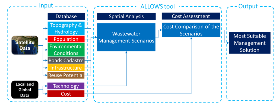
The scenario-generation part of ALLOWS is GIS-based and relies on data that can be mapped. ALLOWS-tool requires five different databases of the settlement: 1) Primary geo-database (geographical data, satellite imaging, open access data on the land surface, physical infrastructures, water bodies etc.), 2) Secondary geo-database (detailed information on physical infrastructures like housing and buildings, streets and already existing wastewater infrastructures), 3) Water database (information on water supply and conveyance, water consumption, connection degree to piped water supply and wastewater disposal, wastewater production, wastewater composition etc.), 4) Technological database (wastewater collection, treatment and reuse technologies, volume or flow, type of effluent, treatment performance, potential risks, O&M requirements, consumable demands, by-products production etc.), 5) Socio-economic database (total population, population growth rates, average household size, land ownership, international and national benchmark prices for all costs associated with technological database like treatment unit, network components, pumping and lifting stations, operation and maintenance costs, labor costs for construction, electricity and water costs, sludge disposal, monitoring costs, etc.). Within the PAVITR Project, it is aimed to generate the first three databases through remote/satellite data. Remaining two databases (technological and socio-economic database) will be generated through local and global data.
The databases are used to map the information on which the wastewater management scenarios will be built. Scenario development then relies on the design of wastewater infrastructures that can be visualized in GIS. The first task concerns the understanding of the local topography and hydrology. After the delineation of micro-catchments, land use and population data processing is carried out. If available, infrastructure data such as roads, existing networks for water and sewer, existing location of potable and wastewater treatment systems, location of springs and bores for potable water etc. are located geographically. These elements form the background, on which the infrastructure scenarios are developed. Once all the elements are in place, the downstream collection points of the micro-catchments are used as location points to install wastewater treatment systems (on land available in the nearby area) or to install pumping station to transfer sewage to another area. Once the main scenario directions are identified, each single scenario is optimised for technical efficiency according to parameters such as building or village density to minimize the technical components and eventually the system costs.
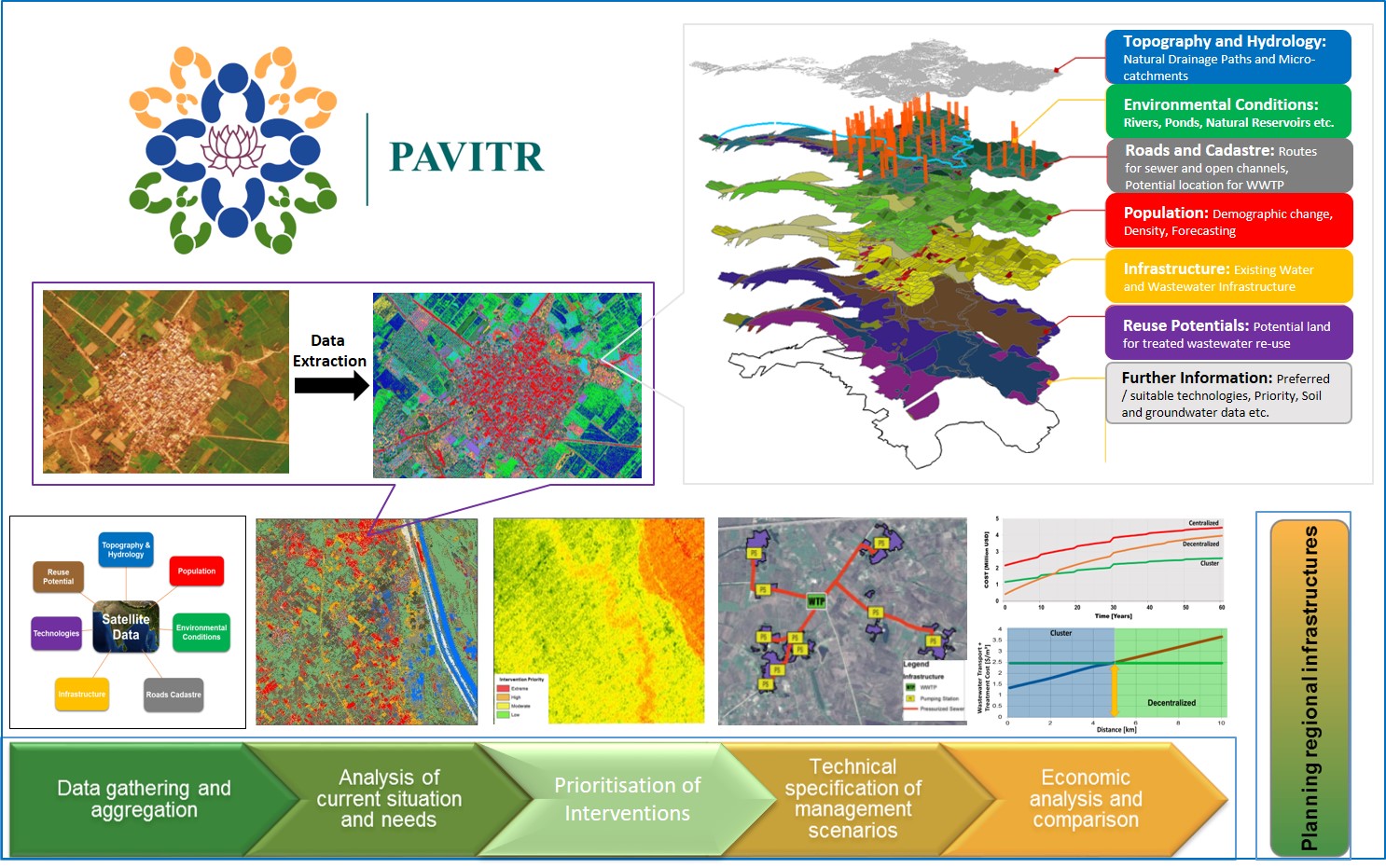
The economic analysis is performed through a Dynamic Cost Comparison that delivers the Net Present Value (NPV) of each scenario. For this, the specifications of each technical component of the wastewater management infrastructure (wastewater collection, transport, treatment and reuse) have to be collected in order for a value (cost-database) to be allocated. The cost of the scenario is thus evaluated over the lifespan of a key equipment (usually the wastewater treatment system or the sewer network), considering capital costs, O&M costs and reinvestment costs. The valuation of the scenarios can thus help the stakeholders to identify investment that will fit their technical requirements and long-term financing capacity.